
Download Daylight Chart – daylight hours, sunrise, sunset, sun path, seasonal changes, geographic coordinates, open source, educational tool, astronomy, geography
Overview
Daylight Chart is a specialized educational tool designed to help users understand and visualize the dynamic nature of daylight throughout the year. By leveraging geographic coordinates, the app delivers precise data on sunrise and sunset times for any location on Earth, enabling users to observe how daylight hours shift with the seasons. This functionality is particularly valuable for individuals interested in astronomy, geography, and environmental awareness. The app serves as a practical resource for students, educators, researchers, and curious learners seeking to explore Earth’s natural cycles and the impact of solar patterns on daily life.
Developed by Arnold A. Howe, the app has been available since 2014, reflecting a long-standing commitment to accessible, science-based tools. Its open-source nature underscores transparency and community-driven development, allowing users to inspect, modify, and contribute to the codebase.
This model supports continuous improvement and fosters trust in the app’s accuracy and integrity. Real-world applications include planning outdoor activities, understanding seasonal variations in different climates, and supporting academic projects in earth sciences. Daylight Chart fills a niche in the mobile ecosystem by offering a focused, data-driven experience that combines education with practical utility.
Key Features & Functionality
- Current Daylight Hours: Provides real-time, location-specific data on the total hours of daylight, helping users plan activities based on seasonal light availability.
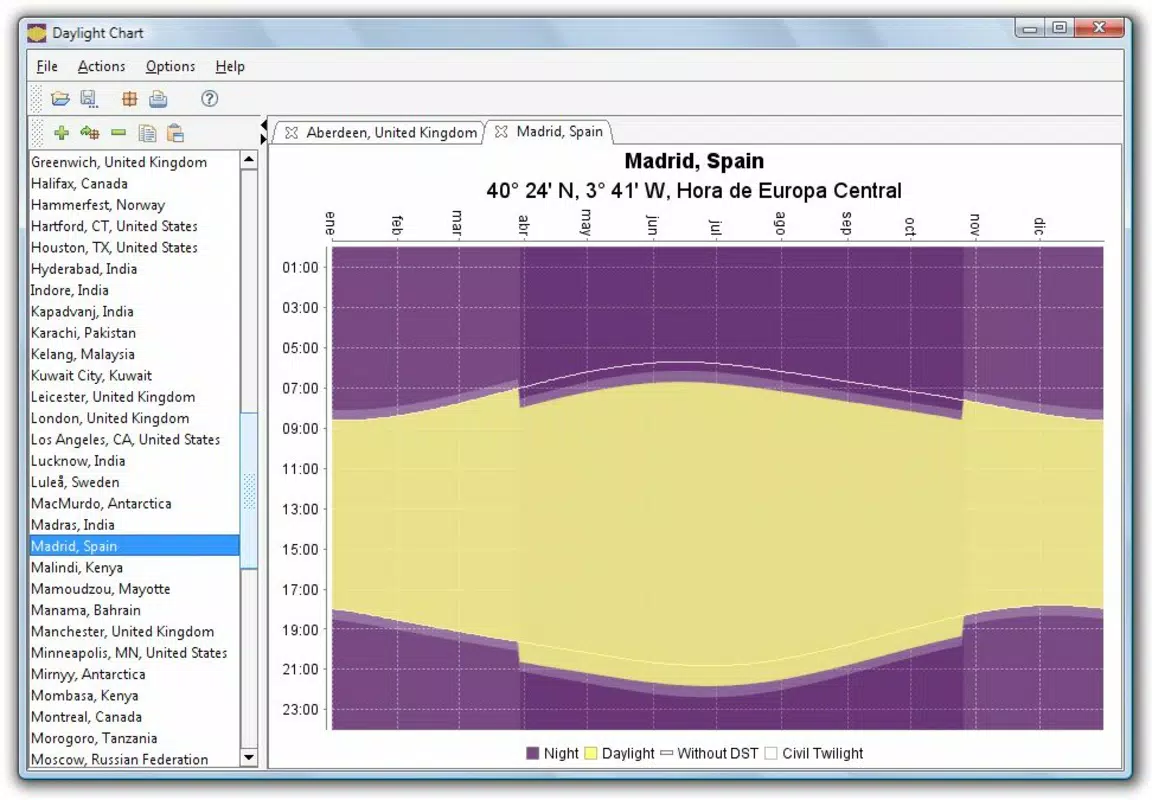
- Visual Sun Path: Displays a dynamic illustration of the Sun’s trajectory across the sky, showing rise and set points and helping users visualize how sunlight intensity and duration change daily.
- Custom Location Input: Allows users to enter longitude and latitude coordinates to generate accurate sunrise and sunset data for any geographic point, enhancing precision and flexibility.
- Open Source Access: The app’s source code is publicly available, enabling developers and educators to study, adapt, and improve the application for educational or research purposes.
- Academic and Cultural Relevance: Designed to support learning about Earth’s axial tilt, seasonal cycles, and cultural traditions tied to daylight changes, such as solstices and equinoxes.
For example, a student studying climate patterns can use the app to compare daylight trends between equatorial and polar regions. A photographer planning a shoot at golden hour can input a specific location to determine optimal timing. Educators can use the visual sun path feature to demonstrate solar movement in classroom settings. The app’s functionality is grounded in real astronomical principles, making it a reliable tool for both casual and academic use.
Interface, UX & Performance
The interface of Daylight Chart is designed with clarity and functionality in mind. The layout emphasizes data presentation, featuring a clean display of sunrise and sunset times alongside a visual sun path diagram. Navigation is straightforward, allowing users to switch between locations or adjust settings with minimal steps. The visual elements are intuitive, using color-coded indicators and simple icons to represent time and solar movement.
Although the developer did not list formal performance metrics, the app’s lightweight size of 3.5 MB suggests efficient resource usage. It is expected to operate smoothly on a range of Android devices, from entry-level to mid-tier models. The responsiveness of the interface appears consistent, with minimal lag during location updates or chart rendering.
Stability is maintained through regular updates, though specific update frequency was not disclosed. Users can expect reliable performance for core functions such as time calculation and visual rendering. The app’s simplicity contributes to a low learning curve, making it accessible to users of varying technical backgrounds.
Platform Compatibility & Technical Requirements
Daylight Chart is available exclusively on the Android platform. The current version is 2.1.3, with a file size of 3.5 MB. The app is free to download and use, with no in-app purchases or subscription models.
While the developer did not specify minimum OS requirements, the app’s lightweight design suggests compatibility with Android devices released in recent years. Specific compatibility details for older or newer Android versions were not provided. Users should ensure their device meets standard Android functionality requirements to run the app without issues.
The absence of complex permissions or background processes further supports broad device compatibility.
Pros and Cons
- Free to download and use with no hidden costs
- Open source, enabling transparency and community contributions
- Accurate, real-time data based on geographic coordinates
- Visual sun path enhances understanding of solar patterns
- Lightweight design suitable for older or low-storage devices
- Supports educational and research applications
- Only available on Android, limiting access for iOS users
- No official update frequency disclosed
- Interface may appear minimalistic to users seeking advanced customization
- Requires manual entry of coordinates for non-recognized locations
- Developer did not provide detailed technical specifications
FAQ
Is Daylight Chart safe to download and use?
Yes, the app is free and open source, with no reported security risks. It does not require excessive permissions, and its lightweight design minimizes potential performance impact.
Can I use Daylight Chart on iOS devices?
Currently, the app is only available on Android. There is no official iOS version, and no information was provided about future platform expansion.
How accurate is the sunrise and sunset data?
The app uses geographic coordinates to calculate sunrise and sunset times based on astronomical models, ensuring high accuracy for the specified location.
Do I need an internet connection to use Daylight Chart?
The app functions offline once the location data is loaded. However, real-time updates may require connectivity for dynamic calculations.
Is the source code available for developers?
Yes, Daylight Chart is open source, and the code is accessible to developers who wish to study, modify, or contribute to the project.
Final Thoughts
Daylight Chart stands out as a focused, reliable tool for anyone seeking to understand the rhythm of daylight across the globe. Its blend of scientific accuracy, visual clarity, and open-source transparency makes it a valuable asset for educators, students, and astronomy enthusiasts. The app’s minimalist design and efficient performance ensure it remains accessible and functional on a wide range of Android devices.
While its availability is limited to Android and lacks advanced customization, its core purpose is fulfilled with precision and integrity. For users interested in seasonal changes, solar patterns, or environmental awareness, this app offers meaningful insights in a compact, user-friendly format. It’s a rare example of a mobile tool that prioritizes education without compromise.
Download Daylight Chart now


